

Geology of the Yemeni island of Socotra [Archives:2005/834/Health]
April 18 2005
 |
For Yemen Times
Many articles were written about Socotra describing its beauty and charm, nevertheless this is not enough. This island is a national treasure not only because of its importance as a tourist attraction, but also because of its geological significance.
The Republic of Yemen is located on the southwest corners of the Arabian Peninsula, while the islands of Soqotra, Abd al Kuri, Darsa, Perim, and Kamaran in the Arabian Sea and southern Red Sea are also part of the Republic of Yemen.
Socotra is the largest and most easterly of a group of islands, which includes Abd al Kuri,
Samha, and Darsa. The surface area of the islands is about 3.650 square kilometers; a broad continental shelf area, particularly well developed on the south side, surrounds the island chain, with an area of approximately 32,000 square kilometers.
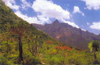
For the most part, the island of Socotra is covered by a veneer of Cretaceous and Tertiary limestones, up to 700 meters in thickness, which forms an undulating, irregular, and in part block-faulted upland plateau ranging from 300 to 900 meters in elevation, overlying an older igneous and metamorphic basement.
There are three main structural uplift areas from the central backbone of Socotra, culminating in the spectacular Haggier Range with peaks rising to 1.500 meters. In other areas, where part of the limestone cover has been removed, recent deposits largely obscure the earlier rocks, particularly along the northern and southern coastal plains and in some of the inland depressions.
OIL AND GAS PREDICTION
Patchy minor oil fields were encountered in the lower Cretaceous section between 1,880 and 2,275 meters. Dolomitic beds within the Permian granite wash section had poor to fair porosity and displayed moderate dry gas fields. These fields increased within the basement, and were interpreted as fracture production. Log analysis indicates that the Permian section is gas saturated. Sedimentological and geochemical analysis of samples and cores from the Samah well indicate that good reservoir beds are present in the Permo-Trias continental sandstones, in carbonate reef flank and shoal deposits, in secondary dolomites, and in sandstone interbeds, particularly in the lower Cretaceous section.
The well contained no thick, continuous sequence of potential source beds, although thin shales between 2,240 and 2,290 meters were determined to be a fairly good source of rocks for oil. It is entirely possible that adequate oil sources can be expected to exist in
Cretaceous and possibly Jurassic beds in deeper parts of the basin where their maturity can also be anticipated.
——
[archive-e:834-v:13-y:2005-d:2005-04-18-p:health]