
A Glimpse of Utma District [Archives:2000/50/Last Page]
December 11 2000
We could say that the fertility of the soil, the high productivity of agricultural crops, the presence of grazing grounds, dense forests, the excellent rates of rainfall, the presence of many springs and rivulets, the climatic diversity from cold, moderate and equatorial, resulted in that diversity of crops suited to the life of many animals. This advantage induced man to settle there and consequently exploit these bounties to provide himself with the requirements of daily life.
This is underlined by the settlers undertaking the construction of the first huge mountainous farming terraces and undertaking farming and animal and birds husbandry.
Early man also utilized his mental capabilities to build citadels and fortresses, dams and weirs for exploiting rain water for sustained agriculture and thus provide food, clothing and bedding, and export the surplus through barter with other regions and thus ensure the other multiple needs of human life.
Location
Utma district lies within the natural extension of the As-Sarah range of mountains that begin in Aden and end at southern peripheries of the Fertile Crescent and the northern part of the Arabian Peninsula. These are mountainous plateaus in the internal central highlands.
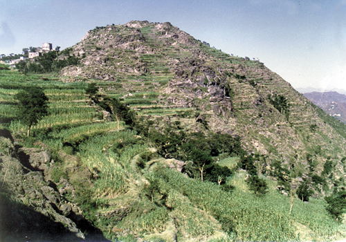
Utma district is made up of high mountains over which straddle the terraces and grazing grounds. It has forests, many internal valleys, flood courses and is the crucible in which gathers the rain water coming down from the high slopes.
It constitutes a primary tributary of Wadi Rama from the north, the north east and west and Wadi Zabeed from the west and south west.
The lowest point in Utma region is 820 m. above sea level. While the highest point is about 2,600 – 2,800m above seal level, especially Samah Citadel and the neighboring peaks, and Bani Asad fort in the western part of the district. Utma lies between the longitudes 44.50 degrees and 43.50 degrees and the latitudes 14.20 degrees and 14.35 degrees.
Among them are many perennial trees with medical properties. This has produced an environmental and biological balance that is rarely found in the regions of the Republic. This makes it imperative that scientists prepare projects covering all plants of the district, for nothing except their economic importance.
We should not also forget the fact that the presence of a verdant and extensive cover has made the districts population bound to the raising of many types of animals and birds. This has also resulted in an environmental balance and the provision of new sources of income for the residents of the district.
Natural beauty
Utma is distinguished by its verdant plains and mountains and the diversity of its climate. It also differs from other Yemeni regions owing to the presence of perennial, medicinal and odorous trees which are listed below:
Civilization landmarks
We have presented a very brief glimpse of Utma districts history. We should also mention part of its distinctive landmarks, the most important of which are the numerous historic citadels and fortresses scattered throughout the district. Each landmark, of course, has its colorful history filled with successive events for centuries.
Here there is no scope to go into the details of such a history and we will have to be content with mentioning some of the more important landmarks, such as Harder fort, Mukhamm fort, Bani Suwaid fort, Al-haddadi fort, A;-muqanza, Al-Dahimi fort…etc.
The district is bounded from the east by Anes district and from the south by Rihab Al-qafr district and from the north by Anes area and Al-Salafyya district and from the west by Kasma and Wassab Al-Ali districts.
District divisions
Utma district comprises five makhaleef – a Himyarite nomenclature naturally – (centers) as follows:
– As-Sahl mikhlaf (center)
– Razk mikhlaf (center)
– Bani Bahr mikhlaf (center)
– Central Himyar mikhlaf (center)
– Samah mikhlaf (center)
These makhaleef (center) encompass 57 quasi-towns and 534 villages made up of 20,469 dwellings houses and 20,249 persons. The districts population represents 6% of the overall population of the Dhamar Governorate according to the 1994 population census.
Agricultural Crops
As mentioned earlier Utma district is distinguished for being a part of the mountainous plateaus giving it a climatic and environmental diversity and resulting in a multiplicity of agricultural crops, which vary between the colder and moderate regions and the equatorial and semi-equatorial ones.
Utma district is considered to be a principal producer of various cereals, especially fine sorghum of 12 types which is exported to many regions of the Republic, especially the central and eastern ones. Furthermore, the mountainous farming terraces and the districts wadis produce white and yellow maize, millet, wheat barley and various types of tubulars. The region is also unique in the production of all types of vegetables and fruit, such as orange, lemon, mango, papaya, mandarin, plums, guava, various types of tamarind and apricots. It also produces ordinary and circular coffee which is to be found in every one of the districts wadis.
We should not forget to mention that Utma district possesses an extensive cover of grazing lands, shrubs and forests which store numerous types of plants.
——
[archive-e:50-v:2000-y:2000-d:2000-12-11-p:./2000/iss50/lastpage.htm]