Al-Taweilah Fortresses and Citadels [Archives:1999/50/Last Page]
December 13 1999
By: Mohammed Al-Shaibi

Al-Taweilah region is two thousand meters above sea level, which constitutes a number of regions and housed judges’ families, including scientific and literary people such as the great Yemeni scientist-judge Salih Bin Mehadi Al-Muqbli, author of the script “Al-Ilm Shamikh” and the book “Al-Abhalh Al-Musaddada fi Funoon Mutaaddida.”
Al-Taweilah region is connected with Msawar lands, and Al-Masanih, Thula, Wallaa in the north, and Hamadan and Sana’a lands in the east, and in the west Al-Mahweet lands, Wadi Surdud and Haraz in the south.
Volcanic formations cover the mountain ridges that extend towards Bani-Al-Khayat region passing through the city center until Al-Mahweet in the west. Al-Taweilah historically were a bridge over which passed the Ottoman invasion forces in the fifteenth century under the leadership of the Ottoman governor Sinan Pasha whose soldiers were positioned in Al-Taweilah town and citadels and which were a center for the movements of these troops.
In modern times, Colonel Mohammed Al-Wadiee, leader of the revolution whose duty was to prevent the counter-forces invasion in 1963, was based here.
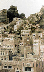
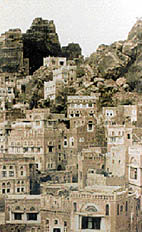
There are five huge mountains that positioned such citadels and fortifications. They do not even have domes, contrary to the important military citadels populated with civil establishments, or defensive fortifications, but these mountains did not lose the property of the defensive fortifications available in other military fortresses. Military fortifications were dug near the top of these semi-conetopped mountains, and many military catering units were built therein. That raises the curiosity and interest of the tourist regarding the origin of these fortifications and the nature of their defensive and security roles regarding the town and the surrounding region that mixes imagination with reality. Real stories are combined with fiction regarding the five citadels and fortresses and their characteristics in defensive performance.
Pride comes from the number of the forts that exist in one area: natives say proudly that there are Al-Qarani fort to the east of the town, Thihyan and Shamsan, and then the giant Al-Manqar fort to the west of the town, in addition to Hajar Al-Sayed citadel and Al-Taweilah fort.
Each citadel and fortress used to play a particular role in security, and military levels, keeping food and maintaining tools. The dome of Al-Taweilah fort has a drinking water spring that used to meet the requirements of other fortresses including Hajar Al-Sayid fortress which was connected by some suspension bridges and was topped by a big one hundred twenty caliber Ottoman canon. Historically, nobody knew how the Ottoman troops carried this canon to Hajar Al-Yad, in spite of the height of its dome at one thousand two hundred ft above land level. The route is so tight that one person can hardly pass through. The canon’s position fell at the hands of the popular national resistance forces which amazed the Ottoman military leadership.
Nothing remains but memories, and the tourist observation to the site as a tourist place because of the unique sample of the middle-age architecture, that has a characteristic engineering pattern.
It is not easy to recognize these particulars when the visitor is amazed by looking at the general frame of conventional architecture that appears at first sight to look similar. In addition to this location, there is another archeological site that is situated nearby some volcanic benches nineteen kms away from Al-Taweilah-Shibam. The individual shall meet a residential archeological building that stands on a volcanic mountain ridge called Al-Kheir fortress.
It is a mountain center polygon shaped like a concave-triangle that is surrounded by residential buildings whose background constitutes the defensive and protective line that can hardly be broken through, except by the only gate situated to the east. It is a sample of the historical residential buildings that used to protect people from foreign invasion Early Yemenis chose to live on mountain tops, and to cultivate the plains that supplied them with crops and protected them from hunger.
——
[archive-e:50-v:1999-y:1999-d:1999-12-13-p:./1999/iss50/lastpage.htm]


