Meuon Island [Archives:2001/30/Last Page]

archive
July 23 2001

images/last_meun1.jpg
Meuon Island is situated in Bab Almandab Strait where it is considered to be the southern waterway of the Red Sea. Unquestionably, it was called the (Second Waterway) after the Suez Canal as it was considered by historians and geographers. It was one of the most strategic Yemeni islands based in the Yemeni territorial waters. It is three miles away from the Yemeni coast to Alsheikh Saeed Mountain. It is 6km away from the Yemeni shore and it is 75feet above the sea level. There are two lighthouses on the island to direct ships to Bab Almandab Straits and the Aden Gulf. It was known as Meuon to Arabs ,but it was known as Perim to the Europeans, whereas the Roman called it Youdori according to its strategic position. The island was the focus of attention of foreign whims and colonizers. It was occupied by the Portuguese in 1513, after the Portuguese leader had failed to occupy Aden and Almakha’s harbors. It was also occupied by the French in 1738 , but they left the island because of the resistance they were encountered with. In 1799 it was also occupied by the Britishers but they were obliged to discard the island, but they came back again to it in 1857 after the occupation of Aden harbor. The Britishers exploited its strategic location during the First and the Second World Wars. They made use of it in blockading the Turks and they transferred the island into a naval military base to supply ships with coal and fuel in 1914 and 1918 during the British occupation of southern part of Yemen. Britain tried to internationalize the island, but it was rejected by inhabitants of the island in particular and the Yemeni people in general.
An Attempt to Internationalize of the Island. In the mid of 1967 the British Government introduced to the UN a proposal concerning the internationalizing the island, ignoring the UN resolutions issued in 1963 and those resolution were amended again in 2965 concerning the occupied southern part of Yemen and the islands belonged to it. On 28/8/1967 the United Assembly in Meuon issued a statement condemning strongly the internationalizing of the island.


images/last_meon2.jpg
Meoun’s Inhabitants Rejecting Internationalizing the Island
The British High Commissioner paid swift visit to the island carrying bags of money to tempt the inhabitants to agree on internationalizing the island, claiming that the policy was for the benefit of the people in the island, but the people discussed the matter intensively and at last they agreed to select social dignitaries to meet the High Commissioner informing him on the peoples’ rejection to internationalizing the island and it being inseparable of the country. Thus, The High Commissioners effort failed.
Its Villages and the Airport.
Meoun’s island comprises five villages:
1-Kumpany village. It consists of rock-built houses particularly the old ones. It was the main harbor for supplying ships with fuel and coal. Oil companies are found in this village together with a small hotel.
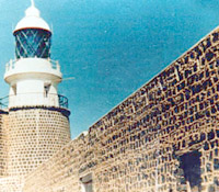
2-Serkally Village. Most of its original inhabitants are fishermen. 3-Betoon village and in it a lighthouse for directing ships.
4-Almanara village
5-Berkot village. It is situated on the coastline opposite Alsheikh Saeed,
Meoun Airport. It is used for air freight.


——
[archive-e:30-v:2001-y:2001-d:2001-07-23-p:./2001/iss30/lastpage.htm]